Photographic observation concept
Within the first project phase in 2005/06, Ulrich Görlich and Meret Wandeler developed a photographic observation concept in collaboration with partners Town of Schlieren and Metron AG. They carried out the first photographic inventory in 2005. The photographic observation concept devises photographic strategies to reveal the process of settlement development, showing it to be the interaction of concurrent changes occurring at different speeds. It forms the basis for the ongoing documentation. The observation concept defines the photographic methods and observation rhythms and determines the locations and objects to be photographed. Its application is independent of individuals; the observation can be carried out by various photographers. The long-term photographic observation examines the impact of the urban development concept on public areas. Photographs are therefore taken only in areas which are accessible to the public.
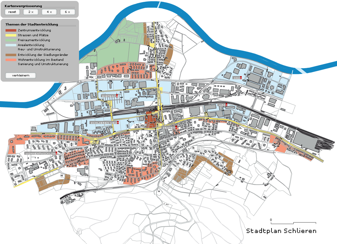
The basis for the photographic observation concept was the urban development concept compiled for Schlieren by Metron AG in 2005. This gave rise to the following topics and issues: town centre development, streets and squares, open space development, development of restructuring areas, development of residential areas and development of the town boundaries. Metron AG and the Town of Schlieren Building and Planning Department specified the districts and areas within the urban area where the topics and issues of urban development could be observed. The function of the photographic visualisation of space is to provide examples. In contrast to the representation of space on a plan, the informative value of photographic observation is not based on complete coverage of the whole urban space, but on the pertinence of situations selected by way of example.
The photographic observation concept provides two contrasting ways of perceiving space: overall views and detailed views. Together they create a flexible image system which enables different evaluations from spatial planning and photographic perspectives. Depending on the area, theme and change process, individual series can be assembled to support the visualisation of examples central to aspects of urban development.
People do not appear in the pictures. When comparing the images, attention should focus entirely on the changes to the urban space and not be distracted by different positions of people in the image. The people are present in the traces they leave behind.
Overall viewsSpatial relationships are illustrated in the overall views. The images show changes in the interplay of buildings, street spaces and open areas. The overall views trace how the measures, interventions and interactions of the various stakeholders in a location and their interaction change the quality of a spatial situation. Elements that are likely to change (e.g. due to demolition, construction and renovation of buildings, modification of traffic routes etc.) can be viewed in conjunction with elements that remain the same. In contrast to architectural photography, it is not an individual building that takes centre stage. Road lanes, squares, potential construction areas and open spaces and/or adjacent buildings are photographed in such a way that all elements that construct the respective spaces are of equal importance.
The overall views are re-photographed every two years from the same location and under the same photographic conditions. The series of overall views from the same location show urban development to be a continuously occurring process. Massive interventions are just as visible as subtle, barely perceptible movements.
In terms of the choice of location, the overall views are designed to be individual images. They make certain features of the selected areas visible as examples. However, due to the standardisation of selected image parameters, the overall views simultaneously form a conceptually arranged image series. All individual images can be combined in different ways. This flexibility provides the conditions required for the comparison of different spaces and situations throughout the urban area.
The following image parameters are specified for all overall views:
- The image location derives from the everyday perception of the user. The view is straight ahead, because the ground floor is critical to everyday perception. The camera height is 170 cm.
- The image location can be determined from the image itself. The camera is always placed on public land.
- A wide-angle focal length is used to convey the spatial depth. The camera is level, not tilted, as the first floor is decisive for the everyday perspective.
- The light is even, so that all details are equally clear and visible.
- Photographs are taken between June and September. The vegetation should be visible but must not define the atmosphere of the location (e.g. a pronounced spring or autumn mood).
The detailed views show selected objects and situations that are characteristic of the different areas and districts. The photographic perspective focuses on objects that characterise the atmosphere of an area and attract the attention of the viewer. The sequences do not form an “inventory”, but exemplify the type of use and structure that are typical of an area. They comprise around 20-30 images per area. The “image” of an area is built up discursively in the sequencing of the photographs. Sequences of detailed views have been taken in the most significant development areas of Schlieren West, Rietbach, Wagi-Areal and in the town centre. A thematic sequence of detailed views shows ground floor uses right across the town along Zürcherstrasse/Badenerstrasse and Uitikonerstrasse/Bahnhofstrasse. Since 2011, when the observation concept of 2005 was extended, detailed views have been taken in the hospital district and in the adjacent residential areas to chart the topic of residential development.
The detailed views are re-photographed thematically every 5 years. Comparing the sequences of detailed views in the same area facilitates comparison of different stages of development in this area.